Earthworks guide: techniques, planning, and best practice
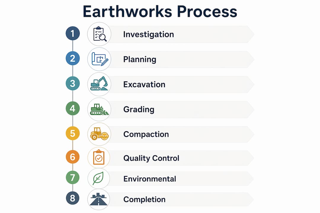
Earthworks is defined as the controlled cutting, filling, moving, and compacting of soil and rock to create stable foundations and workable construction sites. In civil engineering, it forms the first major physical phase of any project, from housing developments to road schemes. This earthworks guide covers site characterisation, excavation sequencing, compaction standards, and modern techniques for managing subsurface obstacles. Gcscontractors applies these principles across groundworks and civil engineering projects, working to UK building regulations and health and safety requirements throughout.
What does a complete earthworks guide cover?
Earthworks is the industry term for the systematic reshaping of land to meet design levels and load-bearing requirements. The process spans stripping topsoil, bulk excavation, cut and fill operations, slope formation, and final grading. Each stage must comply with British Standards and Construction (Design and Management) Regulations 2015, which govern site safety, design coordination, and contractor responsibilities. Poor earthworks planning is one of the leading causes of costly remedial drainage and structural fixes on construction projects. Getting the sequence and specification right from the outset protects both programme and budget.
The scope of earthworks varies significantly by project type. A residential development may require shallow topsoil strip and pad formation, while a commercial scheme may involve deep bulk excavation, retaining structures, and complex drainage networks. Understanding the full range of earthwork techniques before mobilising plant is what separates efficient projects from expensive ones.
How is site characterisation and soil testing conducted?
Site characterisation is the most critical phase of earthworks planning. Insufficient soil sampling risks major design errors that become expensive to correct once excavation begins. A geotechnical investigation must cover multiple locations across the site, not just a single central borehole.
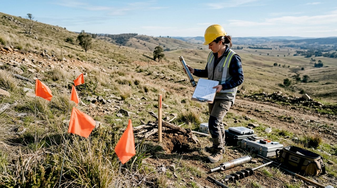
Soil properties vary considerably across even a small plot. Samples taken at building corners and the centre give a far more reliable picture of bearing capacity, moisture content, and contamination risk than a single point. This variability directly affects foundation design, compaction specifications, and the choice of earthmoving plant. A soil contamination assessment should also be completed early, particularly on brownfield sites, to identify any remediation requirements before work begins.
Timing the investigation correctly matters as much as the sampling strategy itself. Permit applications typically take 4–8 weeks to process, so geotechnical work must be completed and reviewed before submission to avoid programme delays. Coordinating soil testing with the planning and permitting process is a site preparation tip that experienced contractors apply as standard.
Key outputs from a thorough site investigation include:
- Soil classification and bearing capacity values for foundation design
- Groundwater levels and seasonal variation data
- Contamination screening results and any remediation requirements
- Suitability assessment for material reuse as engineered fill
- Identification of obstructions such as tree roots, buried structures, or made ground
Pro Tip: Commission a desk study before any physical investigation. Historic maps, aerial photographs, and Environment Agency flood data can reveal buried tanks, old foundations, and drainage runs that a borehole programme alone would miss.
What are the key methods and sequencing principles in excavation and grading?
Earthmoving follows a defined sequence. Departing from that sequence without good reason creates rework, delays, and safety risks. The standard phases for construction earthworks are:
- Site clearance. Remove vegetation, fencing, and surface obstructions. Flag all known utilities with high-visibility markers before any plant moves on site. Pre-flagging utilities prevents costly machine idle time and reduces the risk of service strikes.
- Topsoil strip. Strip and stockpile topsoil separately from subsoil. Mixing the two destroys the topsoil’s agricultural and landscaping value and creates disposal costs that could have been avoided.
- Bulk excavation. Remove material to formation level using hydraulic excavators sized to the volume and access constraints. Track the cut and fill balance throughout to minimise off-site disposal.
- Benching and slope formation. Cut slopes to the specified angle for the soil type. Cohesive soils typically support steeper faces than granular materials, but both require assessment against BS 6031 for earthworks.
- Rough grading. Bring the site to within 150mm of finished formation level. This is the stage where major level corrections are made and drainage falls are established.
- Fine grading. Achieve finished formation levels to tolerances specified in the contract. This prepares the surface for sub-base, foundations, or drainage installation.
Cut and fill balance is central to cost control in any earthmoving guide. Compacted soil volume is typically 65%–85% of the original excavated volume, and rock can swell by 5%–25% when broken out. Failing to account for these swell and shrink factors produces inaccurate material estimates and unexpected haulage costs. Every volume calculation must apply the correct bulking factor for the soil or rock type encountered.
Machinery selection follows directly from soil type and volume. Cohesive clays suit tracked excavators with bucket teeth; granular sands and gravels move efficiently with wheeled loaders. Rock requires hydraulic breakers or specialist splitting equipment before loading. Matching plant to material avoids excessive wear, slow cycle times, and programme overrun.
Pro Tip: Plan haul routes before excavation starts. A poorly positioned spoil heap can block access for concrete deliveries or drainage plant, forcing double-handling that adds days to the programme.
How do compaction, material handling, and quality assurance affect earthworks success?
Compaction is the process of mechanically densifying soil to reduce voids, increase bearing capacity, and prevent future settlement. The specification for compaction is not optional. Soil must be compacted in 150–300mm lifts; attempting to compact thicker layers reduces density and creates a settlement risk that may not appear until structures are loaded. This is one of the most common and costly errors on construction sites.
Moisture content at the time of compaction is equally important. Soil that is too wet will not compact to the required density; soil that is too dry is brittle and resists densification. The target is near the optimum moisture content defined by a Proctor compaction test for the specific material. Equipment selection follows from soil type: vibrating rollers suit granular fills, while sheepsfoot rollers are more effective on cohesive clays.
Quality assurance for compaction relies on field testing. The most widely used methods are:
- Nuclear density gauge testing. Provides rapid in-situ density and moisture readings against the Proctor maximum dry density.
- Dynamic cone penetrometer (DCP). Measures resistance to penetration and gives an indirect indication of compaction quality, particularly useful for granular sub-bases.
- Plate bearing test. Directly measures the load-bearing capacity of the compacted surface, required for road sub-grades and heavily loaded floor slabs.
| Testing method | Best application | Key output |
|---|---|---|
| Nuclear density gauge | Engineered fill layers | Dry density and moisture content |
| Dynamic cone penetrometer | Granular sub-base | CBR value estimate |
| Plate bearing test | Road sub-grade, floor slabs | Modulus of subgrade reaction |
Spoil management affects both cost and environmental compliance. Material suitable for reuse as engineered fill should be stockpiled separately and protected from saturation. Contaminated or unsuitable material requires classification under the Waste Framework Directive before disposal. Segregating materials on site reduces disposal costs and supports the circular economy principles increasingly required by UK planning conditions.
What modern techniques manage subsurface obstacles and environmental challenges?
Urban construction earthworks regularly encounter buried concrete, live utilities, and contaminated ground. Modern urban sites require precise, controlled removal methods rather than brute-force excavation. The consequences of striking a live gas main or crushing a fibre optic duct extend well beyond repair costs.
The standard approach to subsurface risk follows a scan, expose, separate, and remove workflow. Ground-penetrating radar (GPR) surveys identify anomalies before any excavation begins. Vacuum excavation, also known as potholing, then exposes utilities safely without mechanical contact. Controlled separation of buried concrete from surrounding soil reduces disposal costs and minimises site downtime. Hydraulic splitting and concrete demolition shears are low-vibration methods that protect adjacent structures and live services during removal.
Drainage design is a direct output of the grading process. Stormwater management requires a minimum 2% slope grading away from structures to prevent ponding. This is not a guideline; it is a design requirement that affects both planning approval and long-term building performance. For more detail on drainage integration within earthworks, the role of drainage engineers in construction projects is worth reviewing alongside the grading specification.
Environmental protection measures must be active throughout the earthworks phase. Silt fences and settlement ponds control run-off from disturbed ground. Topsoil stockpiles require seeding or covering to prevent erosion. Material reuse targets, where specified in the Environmental Management Plan, reduce lorry movements and carbon output. These are not add-ons; they are contractual requirements on most UK projects above a certain threshold.
Pro Tip: Request a utility record search from all statutory undertakers at least six weeks before excavation. Records are rarely complete, but they narrow the search area and reduce the risk of an unplanned service strike.
Key takeaways
Effective earthworks requires thorough site investigation, accurate volume calculations, and disciplined compaction in specified lift thicknesses to achieve stable, compliant, and cost-effective site preparation.
| Point | Details |
|---|---|
| Site investigation first | Sample soil at multiple locations, including corners and centre, before any design is finalised. |
| Account for volume change | Apply swell and shrink factors to all cut and fill calculations to avoid haulage cost overruns. |
| Compact in specified lifts | Restrict compaction layers to 150–300mm to achieve design density and prevent future settlement. |
| Manage subsurface risk | Use GPR surveys and vacuum excavation to expose utilities safely before mechanical plant moves in. |
| Grade for drainage | Maintain a minimum 2% slope away from structures to meet stormwater management requirements. |
What I have learnt from years on earthworks projects
The single biggest source of programme overrun on earthworks projects is not bad weather or plant breakdown. It is underestimating site variability. I have seen projects where a single borehole in the centre of a plot gave a clean result, only for the excavation to hit made ground, buried rubble, and a redundant drainage run within the first week. The investigation was technically completed; it was just inadequate for the site’s actual complexity.
The second pattern I see repeatedly is treating bulk earthworks as a simple dig-and-dump operation rather than a sequenced process that integrates with every other trade on site. Concrete deliveries, drainage installation, and structural steelwork all depend on earthworks being completed in the right order and to the right level. When the earthworks contractor works in isolation, the downstream trades pay the price.
Clear communication between the geotechnical engineer, the designer, and the earthworks contractor is what separates well-run projects from chaotic ones. The deep excavation safety checklist is a useful reference point for structuring those conversations before plant is mobilised. Getting everyone aligned on formation levels, compaction specifications, and spoil management before work starts costs nothing. Fixing misalignment after the fact costs a great deal.
— George
Gcscontractors: professional groundworks and site preparation
Gcscontractors delivers groundworks and civil engineering services across Cambridge and the surrounding region, covering bulk excavation, grading, drainage installation, and utility trenching. Every project is managed with a focus on health and safety compliance, minimal disruption to live environments, and adherence to UK building regulations.

Whether you need a full site preparation service from strip-out through to formation, or specialist support on a specific earthworks phase, Gcscontractors brings the technical knowledge and site experience to deliver to specification. For a broader overview of what professional groundworks involves, the Cambridge groundworks guide covers the full scope of services available. Contact Gcscontractors to discuss your project requirements.
FAQ
What is the difference between earthworks and groundworks?
Earthworks refers to the bulk movement and shaping of soil and rock to achieve design levels. Groundworks is the broader term that includes earthworks plus foundations, drainage, and below-ground service installation.
How deep does topsoil need to be stripped before earthworks?
Topsoil strip depth depends on the soil profile, but typically ranges from 150mm to 300mm. The stripped material must be stockpiled separately and protected from contamination for potential reuse.
Why do earthworks volume calculations use swell and shrink factors?
Compacted soil occupies 65%–85% of its original excavated volume, while broken rock can expand by 5%–25%. Ignoring these factors produces inaccurate fill estimates and unexpected disposal or import costs.
What slope gradient is required for stormwater drainage on a construction site?
A minimum 2% slope graded away from structures is required to prevent ponding and manage stormwater run-off effectively. This applies to both temporary site grading and permanent finished levels.
When should permit applications be submitted for earthworks projects?
Permit applications should be submitted 4–8 weeks before construction begins to avoid schedule delays. Geotechnical investigations must be completed before submission so that the application reflects accurate ground conditions.
Recommended
- Earthworks Contractors in Cambridgeshire: A Guide to Key Processes – GCS Contractors Ltd
- Earthworks Contractors in Cambridge: A Professional Buying Guide (2026) – GCS Contractors Ltd
- Why plan groundwork: a developer’s guide to success
- The Essential Guide to Setting Out Engineers in Modern Construction – GCS Contractors Ltd