Utility mapping survey: your PAS 128 procurement guide
A utility mapping survey is a PAS 128-compliant investigation that locates, records and classifies underground services before design or excavation work begins. Commission one at three points: during feasibility, when clash-checking a detailed design, and again immediately before any excavation or high-risk dig. Every report you receive should state clearly which parts of the standard it followed and which Quality Levels it achieved for each utility recorded.
Get the timing wrong and the cost lands later, usually as a strike, a redesign, or a stalled excavation team standing idle on site. Get it right, and mapping becomes a design tool rather than a compliance exercise.
- Commission at feasibility to inform site strategy and budget
- Repeat at detailed design to resolve clashes before drawings are frozen
- Verify again immediately before excavation, particularly on high-risk digs
Key Takeaways
Commissioning a PAS 128-compliant utility mapping survey with clearly stated Quality Levels at feasibility, design and pre-excavation stages is the single most effective way to prevent utility strikes and programme delays.
| Point | Details |
|---|---|
| Match quality level to risk | Insist on QL-A physical verification for any utility near foundations, piling or excavation lines. |
| Check the deliverable format | Demand CAD/GIS exports with per-segment metadata, not a single flattened drawing. |
| Name private assets in the brief | Public records stop at the meter, so private drainage and lighting need explicit inclusion. |
| Vet suppliers on evidence | Request sample QL-A records and confirmed NVQ or CICES credentials before awarding the tender. |
| Programme for potholing | Build contingency around verification digs, especially in congested or confined-space corridors. |
Table of Contents
- What does a PAS 128 utility mapping survey actually cover?
- Which detection method should you use, and when?
- What should the survey report and deliverables include?
- How should you vet and procure a utility mapping supplier?
- How long does a utility mapping survey take and what drives the cost?
- How does GCS Contractors use utility mapping on live sites?
- Bring mapping data into a groundworks plan that actually works
- Why quality levels matter more than the survey itself
- Frequently asked questions
- Sources
What does a PAS 128 utility mapping survey actually cover?
PAS 128 is the British specification that governs how underground utility detection and mapping should be carried out and reported in the UK. It exists because utility strikes are expensive, dangerous, and largely preventable when the right detection effort is matched to the right project stage, as I G Surveys sets out in its overview of the standard.
The standard defines four Quality Levels, and understanding the difference matters more than most site teams realise:
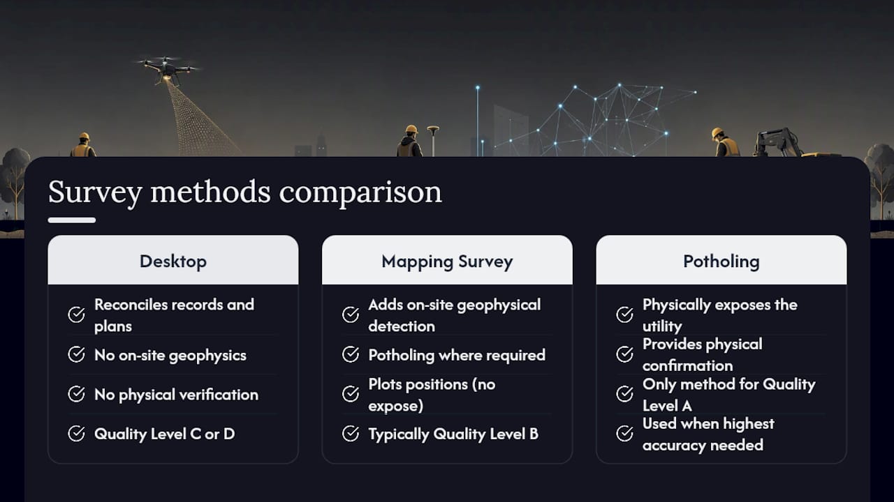
- QL-D: desk-based only, built from statutory records and utility company plans
- QL-C: desktop records reconciled with a site walkover and visible surface features
- QL-B: geophysical detection using tools like GPR and electromagnetic locators, giving a plotted but unverified position
- QL-A: physically verified through non-destructive exposure, typically vacuum excavation, confirming exact position, depth, material and condition
Reaching Quality Level A requires physical confirmation rather than a plotted estimate, according to 4M Analytics. A competent supplier tags every individual utility segment, not the whole site, with the quality level it actually achieved, along with the detection method used and a date. Treat any report that assigns one blanket quality level to an entire drawing with real suspicion.
Which detection method should you use, and when?
No single method covers every utility on a congested urban site. Matching the technique to the material, the ground, and the confidence level you need is the whole discipline.
- Electromagnetic (EM) locators trace live metallic conductors and traceable sondes. Fast and reliable for power and telecoms cabling, but blind to plastic pipework unless a trace wire is present.
- Ground-penetrating radar (GPR) sends radar pulses into the ground and reads the reflections, making it the main tool for detecting plastic and non-metallic pipes. It struggles in clay-heavy or saturated ground, where signal attenuation limits usable depth.
- CCTV drainage inspection pushes a camera through drainage and sewer runs to confirm line, condition and connections that GPR cannot resolve from above.
- Acoustic detection listens for pressure or flow signatures in pipes, useful as a secondary check where EM and GPR readings conflict.
- Vacuum excavation (potholing) physically exposes a utility without the impact risk of mechanical digging, and it is the only route to genuine Quality Level A.
Most competent surveys combine two or three methods and cross-reference the results before committing anything to the final drawing. Where a clash is safety-critical, insist on QL-A exposure rather than accepting a plotted GPR trace.
Pro Tip: If your design brief depends on an exact depth or a live/dead determination for a service near a foundation line, do not accept anything below QL-A on that specific segment, even if the rest of the site is mapped to QL-B.
What should the survey report and deliverables include?
A proper deliverable set gives your design and site teams something they can actually work with, not just a coloured drawing to file away.
- Plan drawings in CAD and GIS formats, georeferenced to your project’s coordinate datum
- An attribute table per utility segment, showing quality level, detection method, and material where known
- Photographs of any potholed or exposed utility, timestamped and referenced to the drawing
- Depth notes recorded at the point of detection or exposure, not extrapolated across a whole run
Coordinate datum consistency matters more than it sounds. A survey pinned to the wrong datum can shift an entire utility corridor by metres once it is overlaid on your setting-out drawings, an error that only surfaces once someone starts digging in the wrong place.
A survey never guarantees complete detection. Abandoned services, deep congestion, and difficult ground conditions all limit what any method can find, which is exactly why a transparent report flags per-segment confidence and states plainly where verification is missing.
Read the limitations section before you read anything else. A report that buries its caveats, or omits them altogether, is telling you more than the drawing itself.
How should you vet and procure a utility mapping supplier?
Procurement is where most of the risk gets managed, or missed. Build your tender brief around what you actually need, not a generic scope.
- Ask for credentials directly: PAS 128 experience, CICES membership or equivalent, and staff holding relevant NVQs for potholing and confined-space work, such as the NVQ diploma in specialist concrete occupations for concrete drilling and sawing. TSA member listings, such as the one held by Utility Mapping Group, offer a useful accreditation check.
- State your target Quality Level per zone, not just for the site as a whole. A car park approach road and a plant room slab rarely need the same confidence level.
- Confirm private asset inclusion explicitly. Public operators typically map only as far as the meter or point of service, and private drainage, lighting circuits or customer-side pipework are commonly missed unless you name them in the brief.
- Request a sample QL-A record from a previous project before you award anything. If a supplier cannot produce one, that is your answer.
- Ask how health and safety is managed during potholing, including permit-to-dig procedures and utility strike protocols.
A vague quality-level claim, a refusal to name detection methods, or no sample evidence of physical verification are all reasons to walk away from a tender.
How long does a utility mapping survey take and what drives the cost?
Expect four phases: desktop record enquiries, on-site detection, verification potholing where required, then reporting and CAD/GIS delivery. A straightforward site can move through all four in a couple of weeks; a congested urban corridor with confined-space entries takes considerably longer.
- Site size and congestion drive the detection phase length more than anything else
- Target Quality Level adds cost and time sharply once potholing enters the scope
- Ground conditions, particularly clay or made ground, slow GPR interpretation and can demand extra passes
- Access complexity, including road closures or confined-space permits, should be priced and programmed separately
Build contingency into your programme rather than your budget alone, and align the survey with enabling works so verification data lands before your excavation team mobilises, not after.
How does GCS Contractors use utility mapping on live sites?
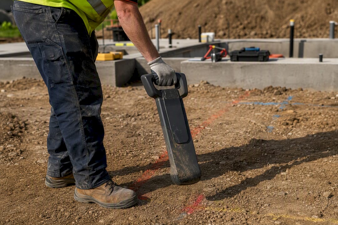
Mapping data changes how we sequence demolition and strip-out work, not just where we dig. Knowing which services are live, which are dead, and which sit within a metre of a proposed foundation line lets us plan enabling works that keep programmes moving without stopping for a discovery.
East Anglian sites bring their own pattern of problems: private drainage runs that predate current records, congested corridors under Cambridge’s older streets, and utility company records that simply do not match what is in the ground. We treat every desktop record as a starting point, not a fact, and reconcile it against verified field data before anyone breaks ground, in line with the deep excavation safety planning approach we apply across our groundworks projects.
- We hand over full CAD/GIS data at project completion, not just a summary drawing
- We flag any segment left at QL-B or below so the next contractor knows exactly where uncertainty remains
Pro Tip: Store your utility mapping data against the site’s permanent coordinate datum, not a temporary site grid. It will save the next phase’s surveyor a genuinely painful reconciliation exercise.
Bring mapping data into a groundworks plan that actually works
A utility mapping survey earns its cost the moment it prevents a strike, but the value compounds when the data feeds directly into how your groundworks team sequences work on site. GCS Contractors builds enabling works, foundations, and demolition programmes around verified utility data from day one, treating the survey as the starting point for safe excavation rather than a paperwork formality.
If you are planning groundworks in Cambridge or East Anglia and want a contractor who reads mapping data properly before mobilising plant, our groundworks and foundation services team can walk through your survey findings and build a sequencing plan around them. For projects still at the design or tender stage, our groundworks subcontractor guide covers how to brief a contractor once your mapping is complete.
Why quality levels matter more than the survey itself
Most disputes over utility mapping do not stem from bad detection work. They stem from someone downstream assuming a QL-B trace was as reliable as a QL-A exposure, and designing or digging accordingly. The technology gets the attention, GPR units and EM locators feature in every sales brochure, but the real value sits in the quality level attribution and whether the supplier is honest about where confidence runs out.
Conventional procurement advice tends to fixate on method: “make sure they use GPR and CCTV.” That misses the point. A supplier can run every method available and still deliver a report with no useful confidence data if the attribution is sloppy or blanket-applied across a site. Ask about methods, certainly, but ask harder about how quality levels are assigned per segment.
If there is one change worth making to how you brief these surveys, it is this: stop specifying “a PAS 128 survey” and start specifying quality levels by zone, with sample QL-A evidence required before award. That single shift moves the risk conversation from the report you receive to the brief you write, which is where it belongs.
Frequently asked questions
What is the difference between a utility mapping survey and a desktop utility search?
A desktop search only reconciles statutory records and utility company plans, equivalent to Quality Level C or D. A full utility mapping survey adds on-site geophysical detection and, where required, physical verification through potholing.
Does a utility mapping survey cover private services on my site?
Not automatically. Public utility operators typically map only to the meter or point of service, so private drainage, lighting circuits and customer-side pipework need to be named explicitly in your survey brief.
How accurate is ground-penetrating radar compared with vacuum potholing?
GPR provides a plotted position without physical confirmation, generally sufficient for Quality Level B. Vacuum potholing physically exposes the utility and is the only method that achieves Quality Level A.
Can I rely on utility company records instead of commissioning a survey?
No. Relying solely on statutory records or legacy maps is a recognised cause of utility strikes, since these records are frequently incomplete or out of date against what is actually in the ground.
When during a project should I commission a utility mapping survey?
Ideally at feasibility to inform site strategy, again during detailed design to resolve clashes, and once more immediately before excavation begins on high-risk digs.
Sources
Recommended
- Roadworks and Paving in Cambridge: A Professional Contractor’s Guide – GCS Contractors Ltd
- Permeable Surfaces: The Professional Guide to Sustainable Paving and Drainage in 2026 – GCS Contractors Ltd
- Surface water management: a practical guide for UK professionals
- S278 Contractors Cambridgeshire: Navigating Highways Works and Council Agreements – GCS Contractors Ltd