Reduced level dig Cambridge: the 2026 contractor’s guide
A reduced level dig is defined as the excavation of a site to a predetermined vertical datum, creating a uniform base level for construction. In Cambridge, this process sits at the heart of every serious site preparation programme, from residential extensions in Newnham to commercial developments near the station quarter. Cut and fill operations involve removing soil from higher ground and placing it in lower areas to achieve a level surface. Getting this right from the outset determines whether your foundation works, drainage runs, and slab formation proceed on programme or grind to a costly halt. Cambridge adds its own complications: protected heritage zones, tight urban access, and ground conditions that shift between clay and gravel within a single plot.
What does a reduced level dig in Cambridge actually require?
A reduced level dig, known in industry practice as cut and fill excavation, reshapes a site to a target vertical datum set by the structural engineer or architect. The “reduced level” refers to the height of a point relative to a fixed benchmark, typically Ordnance Datum Newlyn. Every subsequent construction element, from strip foundations to drainage falls, references this datum. Getting the datum wrong by even 50mm can cascade into misaligned drainage, non-compliant floor levels, and expensive remedial works.
Cambridge construction site preparation carries regulatory weight that many other UK cities do not. Historic England designates and protects monuments across the city, including the Cambridge motte and bailey castle, a Scheduled Ancient Monument under NHLE reference 1006905. That designation is not an isolated example. Iron Age, Roman, and medieval remains sit beneath a wide spread of the city’s development land. Cambridgeshire County Council’s archaeological service and Historic England both expect developers to engage with pre-construction evaluation before any ground is broken. Skipping that step is not a shortcut. It is a liability.

For a thorough grounding in how local archaeology shapes excavation planning, the groundworks in Cambridge guide from Gcscontractors sets out the key constraints and how experienced contractors work within them.
Key tools and machinery for Cambridge sites
Machinery selection is not a procurement afterthought. It is a technical decision that directly affects programme, cost, and site integrity.
| Machinery category | Typical application | Access suitability |
|---|---|---|
| 1-tonne micro digger | Restricted urban plots, rear gardens, listed building curtilages | Narrow gateways, low-headroom sites |
| 3–5 tonne midi excavator | Standard residential and light commercial plots | Standard site access |
| 8–14 tonne excavator | Bulk earthworks, open commercial sites | Wide access roads required |
| Dumper (1–3 tonne) | Spoil removal on confined sites | Tight internal haul routes |
| Laser level and total station | Datum verification throughout excavation | All sites |
Compact 1-tonne micro diggers are the preferred choice for dense urban Cambridge sites, where narrow gateways and protected boundaries make larger plant a genuine risk. Using oversized equipment on a tight site causes damage and delays that far outweigh any saving on plant rental. The rule is simple: match the machine to the access, not to the volume of material.
Before any machinery arrives on site, you need a topographic survey tied to Ordnance Datum, a desktop archaeological assessment, and confirmation of any planning conditions attached to the consent. If the site falls within a Conservation Area or within the setting of a listed building, additional pre-commencement conditions may apply.
How to conduct a reduced level dig: step by step
A well-run excavation follows a clear sequence. Deviating from it, particularly under programme pressure, is where most errors originate.
-
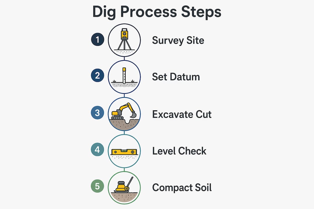
Set out the excavation area. Use a total station or GPS survey instrument to mark the perimeter of the dig and peg the target reduced level at regular intervals across the site. Confirm these pegs against the structural engineer’s drawing before any machine moves.
-
Strip topsoil separately. Remove topsoil as a distinct operation and stockpile it away from the main excavation zone. Topsoil mixed with subsoil cannot be reused as fill and becomes a disposal cost. Segregating it preserves its value for reinstatement or landscaping.
-
Excavate in controlled layers. Excavation must proceed in controlled layers with continuous instrumentation to verify levels at each stage. Working in 150–300mm passes gives the machine operator and the site engineer the opportunity to catch overdig before it becomes a problem.
-
Check levels continuously. A dumpy level or digital laser level should be in use throughout the dig, not just at the end. Assign one person the sole responsibility of calling levels. Do not rely on the machine operator’s eye.
-
Manage cut and fill on site. Where the design allows, retain suitable excavated material for use as engineered fill in lower areas of the site. This reduces haulage costs and disposal fees. Material must be tested for suitability before placement.
-
Address soil variability as it appears. Cambridge ground conditions vary considerably. Made ground, peat lenses, and waterlogged clay all require different responses. Have a contingency protocol agreed with the structural engineer before excavation starts, not during it.
-
Protect exposed formation level. Once the target reduced level is reached, protect the formation from trafficking and rainfall. A blinding layer of lean-mix concrete or compacted hardcore should follow promptly.
Pro Tip: Set a “stop level” 50mm above the final reduced level and carry out a formal level check before the final pass. This single step eliminates the majority of overdig incidents on Cambridge sites.
How to manage common challenges during excavation in Cambridge
Cambridge presents a specific combination of challenges that contractors working in less constrained environments rarely encounter. Addressing them requires preparation, not improvisation.
Tight access and urban constraints
Managing equipment size and local access constraints is the primary factor in keeping Cambridge projects within budget and on schedule. Historic terraced streets, narrow service roads, and protected boundary walls all limit what plant can physically enter a site. The answer is not to force a larger machine through. It is to plan the excavation sequence around the machine that fits.
- Survey access routes before plant hire is confirmed, not after.
- Check overhead obstructions, including cables and tree canopies, that affect machine height.
- Agree a traffic management plan with the local authority where works affect the public highway.
- Confirm turning circles and tipping points for dumpers before the first load moves.
Archaeological discoveries
Unexpected archaeological finds during excavation require immediate work suspension in the affected area and notification of the local planning authority and Historic England. This is not discretionary. Continuing to dig through a find without authorisation carries criminal liability under the Ancient Monuments and Archaeological Areas Act 1979.
Early archaeological assessment and liaison with Historic England prevents the worst surprises. Cambridge archaeological units regularly carry out pre-construction evaluations. Commission one before you tender the groundworks, not after you have signed the contract.
Downtime is the largest hidden cost in Cambridge groundworks. Working with suppliers who provide flexible, quick-turnaround plant hire and correctly-sized equipment for unique site constraints is the most effective way to keep projects on schedule and within budget.
Pro Tip: Build a two-day contingency into your programme specifically for archaeological investigation. If you do not need it, you finish early. If you do need it, you avoid a formal programme extension.
Weather and soil conditions
Wet weather turns Cambridge clay into a material that smears across formation level and contaminates engineered fill. Schedule bulk excavation for drier periods where the programme allows. Keep a supply of geotextile membrane on site to protect exposed formation overnight.
Verification, documentation, and finishing steps after excavation
Reaching the target reduced level is not the end of the operation. It is the point at which the formal verification process begins.
Survey confirmation comes first. A qualified surveyor or engineer must take a grid of spot levels across the formation and compare them against the design reduced level. Any area outside tolerance, typically ±10mm for foundation formation, requires correction before work proceeds.
Compaction testing follows survey confirmation. A plate bearing test or dynamic cone penetrometer test confirms that the formation can carry the design loads. Failing to test and document this stage creates a compliance gap that will surface during building control sign-off or, worse, during a structural investigation years later.
Verification and documentation provide the compliance evidence and safety assurance that building control, structural engineers, and clients require before foundation works begin. Keep records in a format that can be shared digitally with all parties.
| Verification step | Documentation required |
|---|---|
| Survey level check | Grid of spot levels signed by engineer |
| Compaction test | Plate bearing or DCP test certificate |
| Topsoil segregation record | Volume and location of stockpile noted |
| Archaeological watching brief | Written record from archaeologist if required |
| Formation protection | Date and method of blinding or covering noted |
Once verification is complete, the site is ready for the next phase, whether that is strip foundation excavation, pile cap formation, or slab construction. Integrating the reduced level dig sign-off into the overall programme handover prevents the common problem of foundation works starting before the formation has been formally accepted.
Key takeaways
A successful reduced level dig in Cambridge requires matched machinery, continuous level checking, pre-construction archaeological assessment, and formal post-excavation verification before any foundation work begins.
| Point | Details |
|---|---|
| Match machinery to access | Use compact 1-tonne micro diggers on restricted Cambridge sites to avoid damage and delays. |
| Excavate in controlled layers | Work in 150–300mm passes and check levels continuously to prevent overdig. |
| Commission archaeological assessment early | Engage Cambridge archaeological units before tendering groundworks to avoid programme disruption. |
| Document verification formally | Record spot levels, compaction tests, and formation protection before foundation works start. |
| Plan for downtime contingency | Build a two-day buffer into the programme to absorb archaeological or weather-related delays. |
What I have learned from reduced level digs across Cambridge
The single most consistent mistake I see on Cambridge sites is treating the reduced level dig as a straightforward bulk earthworks task. It is not. The combination of archaeological sensitivity, access constraints, and variable ground conditions makes it one of the most technically demanding phases of any Cambridge project.
Contractors who commission a thorough topographic survey and a desktop archaeological assessment before pricing the job consistently outperform those who price from drawings alone. The survey reveals access constraints that change the machinery specification. The archaeological assessment reveals constraints that change the programme. Both affect cost. Discovering either on the first day of excavation is an expensive way to learn.
I have also seen the consequences of poor plant hire decisions. A 13-tonne excavator forced through a 900mm gateway to save a day’s hire cost caused boundary wall damage that took three weeks and a significant sum to repair. The earthworks contractors guide from Gcscontractors covers machinery selection in detail, and the principle is consistent: the right machine for the access, every time.
The relationship with your plant hire supplier also matters more than most developers realise. A supplier who can turn around a replacement machine within hours, or swap a 3-tonne midi for a 1-tonne micro at short notice, keeps your programme moving. One who cannot leaves your team standing idle while costs accumulate.
Finally, the verification stage is where I see corners cut most often. A grid of spot levels takes two hours. Skipping it and discovering a 75mm overdig under a ground-bearing slab takes considerably longer and costs considerably more to resolve.
— George
Gcscontractors: groundworks and excavation services in Cambridge
Gcscontractors delivers specialist groundworks and site preparation across Cambridge, with direct experience of the archaeological constraints, access challenges, and compliance requirements that define construction in this city.
From initial site survey and machinery selection through to formation verification and handover documentation, Gcscontractors manages the full reduced level dig process. The team works within live environments and prioritises health, safety, and local building regulations on every project. For developers and contractors who need a reliable groundworks partner with proven Cambridge experience, contact Gcscontractors for a project consultation and competitive quote. The strip-out and site preparation services complement groundworks delivery, making Gcscontractors a single point of contact for the full pre-construction phase.
FAQ
What is a reduced level dig?
A reduced level dig is the excavation of a site to a predetermined vertical datum, creating a uniform formation level for construction. It is also referred to as cut and fill excavation.
Why does Cambridge require special consideration for reduced level digs?
Cambridge has a high density of protected archaeological sites, including Scheduled Ancient Monuments designated by Historic England. Pre-construction archaeological assessment is required on many sites before excavation can begin.
What machinery is best for a reduced level dig on a restricted Cambridge site?
Compact 1-tonne micro diggers are the preferred choice for tight urban plots in Cambridge, where narrow access and protected boundaries prevent the use of larger plant.
How do I handle an unexpected archaeological find during excavation?
Work must stop in the affected area immediately. Notify the local planning authority and Historic England, and await instruction before resuming excavation in that zone.
What documentation is required after a reduced level dig?
You need a signed grid of spot levels from a qualified engineer, compaction test certificates, a topsoil segregation record, and, where applicable, a written archaeological watching brief record.
Recommended
- Groundworks Contractor in Cambridge: A Professional Reference Guide (2026) – GCS Contractors Ltd
- Professional Demolition Services in Cambridge: The Complete 2026 Developer’s Guide – GCS Contractors Ltd
- Earthworks Contractors in Cambridge: A Professional Buying Guide (2026) – GCS Contractors Ltd
- Groundworks Contractors in Cambridge: The Professional Guide to Civil Engineering & Infrastructure (2026) – GCS Contractors Ltd