Role of ground investigation: what developers need to know
Ground investigation creates a reliable ground model that de-risks design, programme and cost decisions before a single foundation is poured. For any UK construction project where the ground conditions are unknown, suspected to be problematic, or subject to planning conditions, commissioning a site investigation is not optional — it is the foundation of sound project management. The primary outcomes are a ground model with engineering parameters, identification of geotechnical and geoenvironmental hazards, and a set of engineering recommendations with direct cost and programme implications.
Research suggests that adequate ground investigations should represent a minimum of 0.42% of total project cost to effectively mitigate risk. That figure sounds modest, but the consequences of falling short of it are not.
Table of Contents
- What does a ground investigation actually cover?
- Why does ground investigation matter for your project?
- When should you commission a ground investigation?
- How does the four-stage UK site investigation workflow run?
- What investigation methods and tests are used?
- What problems does a ground investigation typically uncover?
- Which UK standards and guidance govern ground investigations?
- What does a ground investigation report contain and how do you read it?
- How do you choose a ground investigation provider?
- How does good ground investigation reduce cost, carbon, and programme risk?
- Key takeaways
- A practical note from a groundworks contractor
- Gcscontractors: groundworks and enabling works from investigation to completion
- Useful sources and further reading
What does a ground investigation actually cover?
A ground investigation is a structured programme of desk study, field reconnaissance, intrusive works, and interpretative reporting, carried out to characterise the ground beneath and around a proposed development. The term covers both geotechnical objectives (soil strength, stratigraphy, groundwater levels, settlement potential) and geoenvironmental objectives (contamination, ground gas, landfill proximity).
Clients sometimes confuse a ground investigation with a simple soil test or a single borehole. A properly scoped investigation is considerably broader:
- Desk study: Review of historic maps, geological surveys from the British Geological Survey (BGS), Environment Agency flood and contamination records, Coal Authority mining records, and aerial photography.
- Field reconnaissance: Walkover survey to identify surface hazards, existing structures, drainage outfalls, and utility risks.
- Intrusive works: Trial pits, cable percussive boreholes, rotary boreholes, and in-situ tests to sample the ground directly.
- In-situ and laboratory testing: Standard Penetration Tests (SPT), Cone Penetration Tests (CPT), particle size analysis, Atterberg limits, contamination screening, and gas monitoring.
- Interpretative reporting: A ground model, engineering parameters, and specific recommendations for design and construction.
Geotechnical findings tell the design team what the ground can carry and how it will behave under load. Geoenvironmental findings determine whether the site is safe to develop, whether remediation is needed, and whether excavated material can be re-used or must be classified as waste.
Why does ground investigation matter for your project?
The practical and financial case for thorough site investigation is well established. Inadequate investigations consistently lead to escalating costs and late completions, with desk studies identified as a low-cost, high-value first step that most projects should never skip.
When ground data is poor, engineers must design conservatively. That conservatism translates directly into over-specified foundations, excess imported fill, unnecessary concrete volumes, and inflated transport movements. Detailed site investigation allows engineers to reduce that conservatism, cutting material use and lowering construction carbon and transport costs. On a large earthworks scheme, the difference between a conservative and an optimised design can be significant.
Programme risk is equally important. Unexpected ground conditions discovered during construction — weak pockets, obstructions, groundwater ingress, or contamination — are among the most common causes of delay claims and contract disputes. A thorough investigation surfaces these issues before the contractor mobilises, when they are far cheaper to address. Case studies in the literature show that investigation budget increases typically add less than 1% to project cost while preventing overruns of 10% or more.
Understanding how ground conditions affect foundation costs is one of the clearest arguments for investing in quality data early.
When should you commission a ground investigation?
Timing matters as much as scope. The ground investigation should be substantially complete before the design is finalised, so that findings can be fully integrated rather than retrofitted. The following triggers should prompt a commission:
- New foundations of any type — residential, commercial, or infrastructure — where ground conditions have not been characterised by recent investigation.
- Change of foundation type or depth on an existing site, particularly where records from previous investigations are incomplete or out of date.
- Significant earthworks — cut-and-fill operations, embankments, retaining structures, or road sub-base construction.
- Known or suspected contamination — brownfield sites, former industrial land, petrol stations, dry cleaners, or sites adjacent to historic landfill.
- Previous mining or filled ground — particularly relevant across much of the East Midlands, South Wales, and parts of East Anglia, where shallow mine workings and historic infill are common.
- Significant groundwater or drainage works — soakaway design, dewatering, sustainable drainage systems (SuDS), or deep drainage installation.
- Planning conditions — local planning authorities routinely attach conditions requiring Phase 1 and Phase 2 contaminated land assessments, particularly on brownfield sites.
- Site enabling works — where enabling works precede the main contractor’s appointment, the GI should inform the enabling scope, not follow it.
For projects following an early contractor involvement (ECI) model, the ground investigation should be commissioned during the pre-construction services agreement (PCSA) phase, so the contractor can price risk accurately and programme intrusive works without delaying design sign-off.
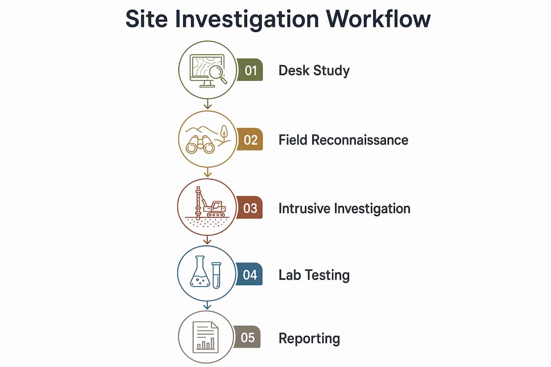
How does the four-stage UK site investigation workflow run?
The standard site investigation workflow follows four stages, though these may overlap and phased investigations are common on complex sites.
Stage 1: Desk study and preliminary risk assessment
The desk study assembles all available secondary data: BGS geological maps and borehole records, historic Ordnance Survey maps, Environment Agency flood zone and contamination data, Coal Authority records, and any previous site investigation reports. The output is a preliminary ground model, a constraints register, and a risk assessment that defines the scope of intrusive works. Duration is typically two to four weeks, depending on data availability.
Stage 2: Field reconnaissance
A walkover survey confirms what the desk study identified and flags what it missed: surface drainage patterns, signs of previous demolition, visible contamination, overhead and underground utility risks, and access constraints. This stage rarely takes more than one to two days on site, but the notes it generates directly shape the intrusive investigation brief.
Stage 3: Intrusive investigation
This is the core fieldwork phase: trial pits, boreholes, in-situ tests, and sampling. On straightforward sites, all intrusive works may be completed in a single mobilisation. On complex or large sites, a phased approach is more effective — targeted initial works informed by the desk study, followed by a second phase once anomalies are confirmed. Fieldwork duration ranges from a few days on a small residential plot to several weeks on a major infrastructure corridor.
Stage 4: Laboratory testing, reporting, and ground model
Samples recovered during intrusive works are sent to an accredited laboratory for testing. The interpretative report then integrates desk study findings, field logs, and laboratory results into a ground model with engineering parameters and specific recommendations. Delivery typically takes four to eight weeks after fieldwork completion, depending on the volume of testing and the complexity of interpretation.
What investigation methods and tests are used?
Intrusive methods
The choice of intrusive method depends on the required investigation depth, the ground type, and what samples or tests are needed.
- Trial pits are excavated by machine to depths of up to 4–5 metres. They give direct visual inspection of soil stratigraphy and allow bulk disturbed sampling. They are cost-effective for shallow investigations but cannot reach deeper strata.
- Cable percussive boreholes advance through soft and cohesive soils using a heavy chisel and are the most common borehole type for UK ground investigations. They allow SPT testing and undisturbed tube sampling at depth.
- Rotary boreholes are used where rock coring is required, or where cable percussive methods cannot advance. They are more expensive but provide continuous core samples through rock and hard strata.
In-situ tests
| Test | What it measures | Typical use |
|---|---|---|
| Standard Penetration Test (SPT) | Soil density and strength | Granular soils, foundation design |
| Cone Penetration Test (CPT) | Continuous soil profile, strength and stiffness | Soft clays, large sites, offshore |
| Plate bearing test | In-situ bearing capacity | Sub-base design, shallow foundations |
| Vane shear test | Undrained shear strength | Soft cohesive soils |
| Permeability / infiltration test | Hydraulic conductivity | SuDS, soakaway design, dewatering |

Non-intrusive geophysics
Ground Penetrating Radar (GPR) and seismic methods can identify buried structures, voids, and lateral variability across a site quickly and non-destructively. Geophysical surveys are effective where lateral variability is an issue but are not routine for all sites. Crucially, the ICE handbook is clear that non-intrusive techniques seldom replace intrusive sampling — geophysics narrows the target, it does not replace the borehole.
Laboratory tests
Common analyses include particle size distribution, Atterberg limits (plasticity), Proctor compaction, triaxial shear strength, California Bearing Ratio (CBR), sulphate and pH testing, and contamination screening by gas chromatography or mass spectrometry. Gas monitoring installations measure methane, carbon dioxide, and oxygen levels over time where landfill gas or ground gas is suspected.
Pro Tip: When deciding between CPT and cable percussive boreholes, favour CPT where you need a continuous, high-resolution soil profile in soft ground across a large footprint. Use boreholes where you need undisturbed samples for laboratory testing, or where the ground is too variable or stiff for CPT advancement. On complex sites, use both.
What problems does a ground investigation typically uncover?
Ground investigations regularly surface conditions that would have caused serious programme and cost problems if discovered during construction. The most common findings and their design implications are:
- Contamination (hydrocarbons, heavy metals, asbestos, made ground): triggers a Phase 2 detailed investigation, remediation strategy, and potentially a waste classification exercise for excavated material. Foundation design may need to account for aggressive ground conditions.
- Weak or compressible soils (soft clays, peat, loose fill): may require piled foundations, ground improvement (dynamic compaction, vibro-stone columns, preloading), or a raft foundation. Settlement calculations become critical.
- High groundwater or a perched water table: affects excavation stability, requires dewatering design, and may influence basement or sub-structure options. Permanent groundwater management may be needed.
- Voids, mine workings, or dissolution features (chalk, limestone, gypsum): require specialist investigation, possibly grouting, and careful foundation positioning to avoid spanning voids.
- Ground gas (methane, carbon dioxide from landfill or natural sources): requires a gas risk assessment and, where risk is confirmed, a gas protection system designed into the floor slab and sub-structure.
A worked example illustrates the cost consequence clearly. A developer commissions a residential scheme on a former market garden site in Cambridgeshire. The desk study flags made ground and a historic pond. Intrusive investigation confirms 2.5 metres of soft fill overlying firm clay. Without that data, the design team would have specified strip foundations. With it, they specify short-bored piles to firm clay, avoiding differential settlement and the programme risk of discovering the fill during excavation. The pile specification adds cost, but the alternative — discovering the problem on site — would have cost considerably more in delay and redesign. Understanding foundations best practice in the context of ground conditions is where GI data pays for itself most directly.
Which UK standards and guidance govern ground investigations?
A credible ground investigation report should reference and comply with the following:
| Standard / Guidance | Scope |
|---|---|
| BS 5930 (2015 with amendments) | Primary UK code of practice for site investigations; covers planning, fieldwork, logging, and reporting |
| CIRIA guidance (various) | Practical guidance on contaminated land, ground gas, SuDS, and earthworks |
| Environment Agency / DEFRA contaminated land guidance | Statutory framework for contaminated land assessment under Part IIA of the Environmental Protection Act 1990 |
| ICE Site Investigation in Construction series | Practitioner guidance on procurement, supervision, and reporting |
| HSE CDM Regulations 2015 | Duty to identify and manage ground-related risks as part of pre-construction information |
To check whether a report meets recognised practice, look for the following:
- Method statements for each intrusive technique, referencing BS 5930 logging and description standards.
- A sampling strategy with justified hole spacing and depths relative to the proposed works.
- Chain of custody documentation for contamination samples, with laboratory UKAS accreditation confirmed.
- Test standards cited for every laboratory result (e.g. BS 1377 for soil testing).
- A clear statement of the limitations of the investigation, including areas not investigated and conditions that may have changed.
What does a ground investigation report contain and how do you read it?
A well-structured report typically contains the following sections, in order; for detailed guidance on reporting and workflows, see these ShearWise tutorials | Training videos.
- Executive summary: The single most important section for a developer or project manager. It should state the key findings, principal hazards, and headline recommendations in plain language. If the executive summary is vague or absent, treat that as a red flag.
- Desk study: Summary of secondary data sources, historic land use, and preliminary risk assessment.
- Ground model: A conceptual or numerical model of the subsurface, usually presented as cross-sections and a written description of the stratigraphy and groundwater regime.
- Borehole and trial pit logs: Detailed field records of each exploratory hole, including soil descriptions, sample depths, and in-situ test results.
- Laboratory test results: Tabulated data with test standards referenced.
- Interpretative section: The engineer’s analysis of the data, including derived parameters for design (bearing capacity, settlement, permeability, contamination risk).
- Engineering recommendations: Specific advice on foundation options, earthworks, drainage, remediation, and further investigation if required.
- Limitations: A statement of what the investigation did not cover and where uncertainty remains.
Red flags to watch for include: sampling density that seems low relative to the site area and proposed works; absent or incomplete groundwater monitoring data; laboratory results with no test standards cited; and recommendations that are generic rather than site-specific. A report that does not reference BS 5930 at all should prompt a direct question to the author.
How do you choose a ground investigation provider?
Selecting the right provider is as important as commissioning the investigation at all. A poorly supervised investigation with insufficient sampling is worse than a well-scoped one, because it creates false confidence.
Essential credentials to verify
- A chartered geotechnical engineer or engineering geologist (CEng or CGeol, typically a member of the Geological Society or the British Geotechnical Association) should lead the interpretation and sign off the report.
- Evidence of relevant project experience in similar ground types and project scales — ask for examples.
- UKAS-accredited laboratory for all soil and contamination testing.
- Appropriate professional indemnity and public liability insurance.
What to include in your investigation brief
- Clear statement of the proposed development: type, footprint, loads, and foundation concept.
- Target investigation depths, referenced to the proposed foundation level and anticipated stratigraphy.
- Number and type of exploratory holes, with justification relative to the site area and risk.
- Sampling and testing schedule, including both in-situ and laboratory requirements.
- Health, safety, and environmental controls, including utility clearance before intrusive works.
- Reporting requirements: format, contents, and delivery programme.
Red flags to avoid
- Overly low fixed-price quotes with no scope breakdown — these almost always involve insufficient sampling density or absent supervision.
- No provision for phased or adaptive works if unexpected conditions are found.
- Supervisory staff without chartered geotechnical qualifications.
- No mention of BS 5930 or relevant test standards in the proposed methodology.
For guidance on selecting groundworks and ground investigation partners, the groundworks subcontractor selection guide sets out the key technical and commercial criteria to apply.
How does good ground investigation reduce cost, carbon, and programme risk?
The financial argument for investing in quality ground data is well supported. Treating GI budget as discretionary is a false economy: a relatively small increase in investigation spend often prevents much larger remedial costs during construction.
“Engineers emphasise that poor-quality ground data forces excessive design conservatism, which inflates material use and carbon footprint; targeted, high-quality ground investigation enables more efficient, sustainable designs.” — Studylib / site investigation in construction
The sustainability argument is increasingly relevant. Over-specified foundations require more concrete and steel. Unnecessary imported fill generates additional lorry movements and embodied carbon. On a scheme where the structural engineer can justify a shallower or narrower foundation because the ground model confirms adequate bearing capacity, the material savings are real and quantifiable.
For enabling works contractors and groundworks specialists, the quality of the GI report directly shapes the accuracy of their pricing and programme. A clear ground model with reliable parameters allows a groundworks contractor to price earthworks, drainage, and foundation packages with confidence rather than loading risk into the tender. That benefit flows directly to the developer through more competitive and reliable pricing.
Key takeaways
Ground investigation is the single most cost-effective risk management tool available to a UK developer or contractor before construction begins.
| Point | Details |
|---|---|
| Commission GI before design is fixed | The investigation should be substantially complete before foundation design is finalised, so findings are fully integrated. |
| Budget a sufficient proportion of project cost | Research identifies 0.42% as the minimum spend to effectively mitigate ground risk; falling below it correlates with cost overruns. |
| Insist on chartered supervision | Specify a chartered geotechnical engineer or engineering geologist to supervise fieldwork and sign off the report. |
| Check report conformance to BS 5930 | Every credible UK ground investigation report should reference BS 5930 and cite BS 1377 for laboratory test results. |
| Gcscontractors for enabling and groundworks | Gcscontractors delivers groundworks and enabling works in Cambridge and East Anglia, with experience translating GI findings into accurate, compliant construction programmes. |
A practical note from a groundworks contractor
One of the most consistent problems on site is the gap between what a ground investigation report says and what the groundworks team actually knows about it when they mobilise. The GI report gets filed with the design team, the contractor receives a summary in the tender documents, and the operatives on site have never seen the borehole logs. That break in continuity is where interpretation errors and programme delays are born.
The fix is straightforward but rarely enforced: the geotechnical specialist who authored the report should attend the pre-start meeting and walk the site with the groundworks foreman. Key findings — the depth to firm strata, the groundwater level at the time of investigation, the location of any anomalous zones — should be marked on a site drawing that lives in the site office, not in a PDF on a project server.
When unexpected conditions are encountered during excavation, the groundworks contractor should flag them immediately and formally, with photographic records and a written note to the design team. That triggers the right response: a decision on whether additional investigation is needed, rather than a quiet workaround that stores up a problem for later. Maintaining safe practices on groundworks sites includes knowing when to stop and ask, not just when to dig.
Gcscontractors: groundworks and enabling works from investigation to completion

Gcscontractors delivers groundworks and civil engineering services across Cambridge and East Anglia, working directly from GI findings to programme and price enabling works, foundations, drainage, and site preparation with accuracy. Where other contractors load risk into their tenders because the ground data is thin, Gcscontractors works with clients and their geotechnical advisers to translate a sound ground model into a reliable, compliant construction programme.
The practical benefits of using an integrated enabling works and groundworks contractor include a single point of contact from site clearance through to drainage and foundations, a programme aligned with the GI findings from day one, and a team experienced in flagging unexpected ground conditions quickly and formally. For developers and building contractors in Cambridge and across East Anglia, the next step is straightforward: contact Gcscontractors to discuss your project’s enabling and groundworks requirements, or visit the site setup and enabling works page to see how the service scope aligns with your programme.
Useful sources and further reading
The following authoritative references are the primary sources practitioners should consult when specifying, procuring, or reviewing a UK ground investigation.
BS 5930:2015 (with amendments) — Code of Practice for Ground Investigations
The principal British Standard governing all aspects of site investigation in the UK, from planning and fieldwork to logging, sampling, testing, and reporting. Every ground investigation report for a UK project should reference it. Published by BSI; amendments noted by CLAIRE.
ICE Site Investigation in Construction series
Four-volume practitioner guidance covering management, procurement, specification, and supervision of ground investigations. Particularly useful for clients and project managers who need to understand what to ask for and how to check what they receive.
CIRIA guidance
CIRIA publishes practical guidance on contaminated land risk assessment, ground gas, SuDS design, and earthworks. Titles relevant to most UK development projects include the CIRIA contaminated land risk assessment guide and the CIRIA ground gas handbook.
Environment Agency and DEFRA contaminated land guidance
The statutory framework for contaminated land assessment under Part IIA of the Environmental Protection Act 1990. The Environment Agency’s guidance and regulatory framework is the primary reference for Phase 1 and Phase 2 contaminated land assessments.
The Coal Authority
For sites in former coalfield areas, the Coal Authority holds records of mine entries, workings, and coal seam depths. A search should be part of every desk study on potentially affected sites.
British Geological Survey (BGS)
The BGS provides geological maps, borehole records, and geohazard data that form the backbone of any desk study. The GeoIndex online tool is freely accessible.
HSE CDM Regulations 2015
The CDM Regulations place explicit duties on clients and designers to identify and manage ground-related risks as part of pre-construction information. Ground investigation findings must be included in the health and safety file.
For specialist geotechnical or geoenvironmental advice, the British Geotechnical Association maintains a directory of chartered practitioners and publishes technical guidance relevant to UK ground conditions and practice.