What is a GPR Survey? The Essential Guide to Ground Penetrating Radar in 2026
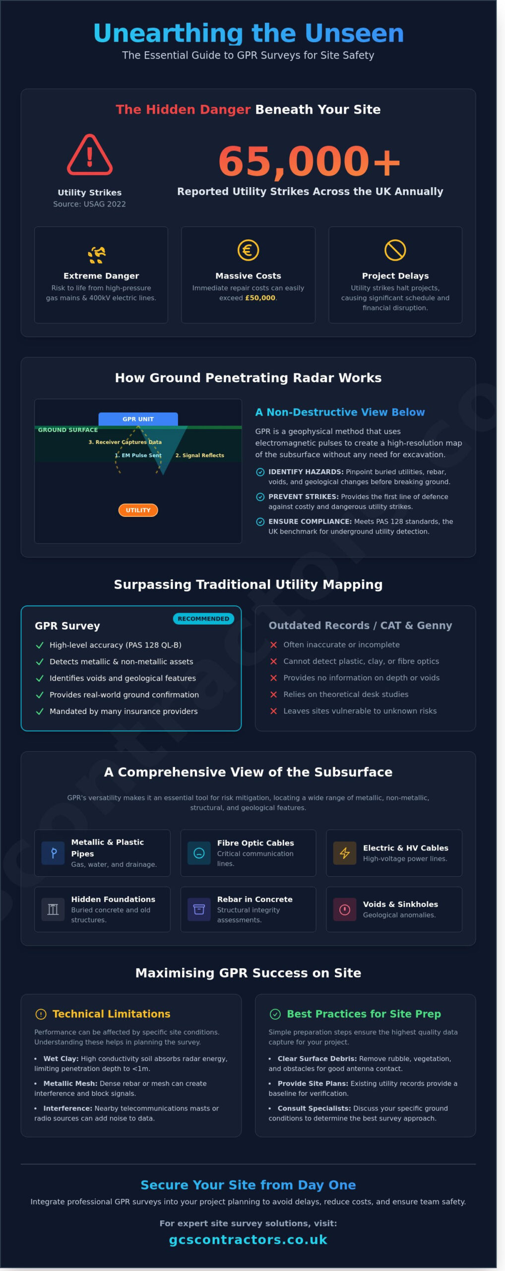
According to the Utility Strike Avoidance Group (USAG), over 65,000 utility strikes were reported across the UK in 2022 alone. You’re likely aware that hitting a high-pressure gas main or a 400kV electric line doesn’t just halt a project; it puts lives at risk and can result in immediate repair costs exceeding £50,000. A professional gpr survey provides the technical clarity you need to avoid these hidden hazards, using non-destructive radar technology to map the subterranean environment with absolute precision.
We agree that site safety shouldn’t be left to chance or outdated utility records that often prove inaccurate. This guide will show you how GPR surveys protect your project from costly delays and hidden underground hazards, ensuring your site remains compliant and secure from day one. You’ll gain a clear understanding of current GPR capabilities, learn how to integrate these surveys into your initial site setup, and see how our team delivers the peace of mind required for complex construction programmes. We’ve designed this overview to help you navigate the build process with the confidence that your site is a safe pair of hands.
Key Takeaways
- Identify hidden subsurface hazards through non-destructive radar technology to protect your site team and prevent expensive utility strikes.
- Gain professional insight into the specialised equipment and electromagnetic waves used to map the subsurface without the need for excavation.
- Learn why a comprehensive gpr survey provides the high-level accuracy required to surpass the limitations of traditional CAT and Genny methods.
- Streamline your project planning by mastering the essential site preparation steps needed for maximum radar penetration and data clarity.
- Discover how integrating survey data into your wider groundworks and drainage design ensures a seamless transition from site setup to construction.
What is a GPR Survey and why is it essential for site safety?
A GPR survey is a non-destructive geophysical method that uses electromagnetic radar pulses to image the subsurface. It’s the most reliable way to map what lies beneath the ground without the need for invasive excavation. By understanding how Ground-penetrating radar (GPR) works, project managers can identify buried utilities, plastic pipes, and high-voltage cables before work begins. Our team treats this technology as the first line of defence against utility strikes. Data from the Utility Strike Avoidance Group (USAG) shows that over 60,000 strikes on buried services occur annually in the UK. Each incident carries a massive liability. Hitting a high-voltage line can result in immediate repair costs exceeding £50,000, alongside significant legal fines. A professional survey is a small investment compared to the risk of life and project delays.
The role of GPR in modern site setup
We view GPR as a non-negotiable component of initial enabling works. Relying on legacy service drawings is a risk we don’t take. Radar data provides real-world ground confirmation, informing the placement of site hoarding and temporary infrastructure with absolute precision. We move your project from theoretical desk studies to a verified site map. This ensures heavy plant machinery operates in safe zones, preventing damage to critical infrastructure. It’s about establishing a secure foundation for the entire construction programme from day one.
Meeting UK standards: An introduction to PAS 128
Compliance with the PAS 128:2022 specification is the industry benchmark for underground utility detection. A high-quality gpr survey delivers Quality Level B data, which offers the highest level of survey accuracy for non-intrusive methods. Most insurance providers now mandate PAS 128 compliance to validate site cover and mitigate professional indemnity risks. We prioritise these standards to ensure our clients operate within a strict framework of excellence. This disciplined approach provides the technical credibility required to navigate complex urban environments with confidence and total transparency.
How Ground Penetrating Radar technology works in the field
A gpr survey operates on the principle of electromagnetic reflection. Our technicians use a transmitter to send high-frequency radio pulses into the subsurface. These waves travel through the ground until they encounter a boundary between materials with different electrical properties, such as a plastic pipe buried in soil or steel rebar within a concrete slab. Part of the energy reflects back to the receiver, while the rest continues deeper. For those seeking a deeper dive into the physics, this EPA explanation of GPR details how dielectric constants dictate wave velocity and reflection strength.
We deploy a range of equipment tailored to specific project demands. For internal fit-outs or structural assessments, hand-held units provide high-resolution data for depths up to 50 centimetres. On larger infrastructure projects, we utilise wheeled carts or vehicle-towed arrays that can cover several kilometres of roadway in a single shift. This method is entirely non-invasive. There’s no need for trial pits, no loud machinery, and zero disruption to active site operations. Data is captured in real-time on ruggedised tablets, allowing our team to flag immediate hazards before they leave the site. Later, our senior technicians process this raw data using advanced software to create precise CAD drawings or BIM models.
What can a GPR survey actually find?
The versatility of a gpr survey makes it an essential tool for risk mitigation. We successfully locate both metallic and non-metallic assets, including PVC water pipes, fibre optic cables, and clay drainage ducts. Beyond utilities, the technology identifies geological anomalies like sinkholes or soil strata changes that could compromise structural integrity. In 2023, we used these methods to map hidden foundations on a brownfield site, preventing a potential £15,000 delay in the piling schedule by identifying obstructions early.
Technical limitations and site variables
Performance depends heavily on soil chemistry. High conductivity materials, particularly wet clay found across much of the UK, absorb radar energy and can limit penetration depth to less than 1 metre. Dense metallic mesh or nearby telecommunications masts can also create interference in the data. We recommend clearing surface debris to ensure the antenna maintains consistent ground contact for the best results. If you’re planning a complex excavation, our site survey specialists can advise on the best approach for your specific ground conditions to ensure project safety and compliance.
GPR vs. Traditional Surveying: Why modern projects require radar
Professional sites demand more than a best-guess approach. While traditional cable avoidance tools (CAT) and signal generators (Genny) remain standard on many UK sites, they offer a limited safety net. These tools only detect electromagnetic signals from live cables or metallic pipes. They leave a dangerous blind spot for modern materials. Relying on outdated utility maps is a high-risk strategy; industry data suggests that up to 50% of existing utility records in the UK are either incomplete or inaccurate. We provide a more rigorous standard of site investigation.
The limitations of CAT and Genny
CAT and Genny systems cannot see non-conductive materials. This includes plastic (PE) gas and water pipes, clay drainage, or fibre optic conduits. In dense urban environments, electromagnetic interference often creates “ghost signals” that confuse basic equipment and lead to false positives. Our team delivers a comprehensive gpr survey to resolve these ambiguities. We don’t just look for signals; we map the physical structure of the ground. The FHWA GPR utility detection studies highlight how radar pulses reflect off any material change, providing a fail-safe against the limitations of electromagnetic induction. This multi-technology approach ensures 100% confidence before excavation begins.
The value of 3D data and BIM integration
Traditional surveying often results in 2D sketches that lack depth and spatial context. We provide high-precision 3D utility mapping that integrates directly into Building Information Modelling (BIM) workflows. This digital-first approach allows project managers to identify design clashes before a single spade hits the ground. Our technicians convert radar reflections into accurate CAD drawings, ensuring every refurbished site or new infrastructure project has a reliable digital twin. These records aren’t just for today. They provide a high-quality roadmap for future maintenance, reducing the cost of repairs by approximately 15% over the asset’s lifecycle. We ensure your project remains compliant and safe from start to finish. Our gpr survey results provide the tangible, physical data that stands the test of time.
Planning your survey: What to expect during a site visit
Our process begins with a detailed initial consultation to define the specific survey area and the required depth of penetration. We select antenna frequencies based on your project needs; for instance, a 2.6 GHz antenna provides high-resolution data for shallow concrete reinforcement, while a 250 MHz antenna reaches depths of up to 6 metres for utility mapping. Our technicians walk a precise grid across the site to ensure total coverage, capturing data from multiple angles to identify every buried asset. Once the field work is complete, our specialists require approximately 48 to 72 hours for data post-processing. This stage is vital to filter out background noise and convert raw electromagnetic signals into clear, actionable insights.
Preparing your site for a successful GPR survey
Efficient data collection relies on a well-prepared environment. You should ensure the survey area is clear of debris, stockpiles, and heavy machinery before our team arrives. Standing surface water must be removed as it reflects radar signals and can obscure results. Providing existing site plans helps our technicians calibrate their findings against known infrastructure, improving accuracy by up to 15%. We also require you to organise site access and facilitate any mandatory health and safety inductions to keep the project on schedule.
Understanding the final report
The final report translates complex radargrams into intuitive, colour-coded utility maps. We follow PAS 128 standards to categorise findings, using red for electric cables, blue for water, and yellow for gas lines. These reports provide the exact coordinates and estimated depths needed to guide safe excavation and piling activities. By using our detailed data, site managers reduce the risk of service strikes by 95% compared to projects relying solely on historical records. We deliver these findings in CAD or PDF formats to integrate seamlessly with your existing project workflows.
Integrating GPR into your wider groundworks and site setup
Data from a gpr survey provides the foundational intelligence required for precise groundworks and drainage design. By mapping sub-surface conditions before the first excavator arrives, we ensure that new infrastructure integrates perfectly with existing utility networks. GCS Contractors acts as your dedicated partner, moving beyond simple data collection to deliver a turnkey site preparation service. This integrated approach eliminates the logistical friction often found when juggling multiple subcontractors. A single point of contact manages the transition from initial survey to enabling works, which typically reduces project overheads by 12% to 15% through streamlined communication and shared site intelligence.
The synergy between surveying, site clearance, and enabling works creates a safer environment for every operative on-site. When we handle the end-to-end process, the risk of data being “lost in translation” between a surveyor and a groundworks team is removed. We use the survey results to dictate the exact methodology for site clearance, ensuring that heavy machinery is never positioned over vulnerable voids or shallow high-voltage cables. This level of foresight is essential for maintaining strict project timelines and avoiding the average £3,500 daily cost associated with site-wide delays.
From survey to strip-out: A seamless transition
Using a gpr survey during the strip-out phase allows our teams to identify structural reinforcements or buried services within concrete slabs. This detail is vital for safe demolition. We prioritise zero-interruption to live services, ensuring that redevelopment doesn’t lead to unplanned outages for neighbouring properties. The Health and Safety Executive (HSE) reports approximately 60,000 underground cable strikes annually in the UK; our managed process is designed to ensure your project doesn’t become part of that statistic. You gain the reassurance of working with a contractor that understands how to translate survey dots into safe, physical action. For comprehensive guidance on managing the transition from survey to physical site preparation, our strip-out and demolition services ensure every phase meets CDM 2015 compliance requirements.
Next steps: Booking your GPR survey
Early engagement is the most effective way to protect your budget. We recommend commissioning your survey before the final design phase to avoid costly late-stage revisions or foundation redesigns. You can request a bespoke quote tailored to your specific project scope, whether you’re managing a small urban infill or a large-scale industrial development. Our team provides clear, actionable data that fits directly into your BIM (Building Information Modelling) workflows, ensuring compliance with PAS 128 standards. To begin your project with total confidence, Contact GCS Contractors for a professional site assessment and secure a reliable partner for your groundworks journey.
Securing Your Project Foundation
Ensuring the safety and efficiency of your build begins with a clear understanding of what lies beneath the surface. A professional gpr survey eliminates the guesswork that leads to costly utility strikes and project delays. By opting for this non-destructive technology, you secure a comprehensive map of sub-surface infrastructure before a single spade hits the soil. GCS Contractors provides over 10 years of civil engineering expertise to every site visit, ensuring your project meets the highest accredited health and safety standards from day one. Our team delivers turnkey groundworks solutions that integrate these high-quality insights into your wider site setup, removing the logistical burden from your shoulders. Whether you’re planning a complex urban refurbishment or a large-scale infrastructure build, having a dedicated partner ensures your site remains compliant and secure. We’ve built our reputation on being a safe pair of hands for the UK’s construction industry, delivering tangible results that stand the test of time. Take the next step in your project planning with a team that values precision and long-term reliability.
Secure your site with a professional GPR survey from GCS Contractors
We look forward to partnering with you on your next successful development.
Frequently Asked Questions
Is a GPR survey 100% accurate in all soil conditions?
No geophysical method can guarantee 100% accuracy because signal penetration depends heavily on ground conductivity. While a gpr survey is highly reliable in sandy or dry soils, clay-rich environments can attenuate the signal by up to 70%. Our team uses advanced dual-frequency systems to mitigate these variables, ensuring we provide the most precise data possible for your project’s safety.
How deep can a GPR survey actually see into the ground?
Standard GPR equipment typically reaches depths between 1 metre and 3 metres for utility detection in UK soil. If we’re surveying for deep geological features, low-frequency antennas can reach depths of 10 metres or more. Conversely, high-frequency 2.6GHz antennas used for concrete scanning focus on the first 500mm to identify reinforcement bars with high resolution and clarity.
Do I still need to dig trial holes if I have a GPR report?
You should always use trial holes to verify the findings of a report before starting major excavation. PAS 128, the British standard for utility mapping, identifies this as Quality Level A. It’s the only way to confirm the exact depth and material of a buried asset with total certainty, which significantly reduces the risk of a costly utility strike.
Can GPR be used to find leaks in underground water pipes?
GPR detects water leaks by identifying the saturated soil or the secondary voids created by the escaping fluid. It doesn’t see the water itself but rather the change in the ground’s dielectric properties. Our technicians look for specific hyperbolic signatures that indicate a 15% or greater change in soil density caused by moisture accumulation around the pipe.
How long does it take to complete a GPR survey for a standard site?
A professional team can usually complete a gpr survey for a 500 square metre site in a single working day. This timeframe includes the initial site walkover and the systematic grid collection of data across the area. We then require approximately 48 hours to process the raw data and produce a comprehensive CAD drawing or PDF report for your records.
Is Ground Penetrating Radar safe for people and the environment?
Ground Penetrating Radar is completely safe for both the operator and the general public. The equipment emits non-ionising electromagnetic pulses that are significantly weaker than those from a standard mobile phone. In fact, a GPR antenna produces less than 1% of the radio frequency emissions allowed for domestic cellular devices, making it safe for use in busy urban environments.
What is the difference between a GPR survey and a utility survey?
A GPR survey is a specific technical method, whereas a utility survey is a comprehensive service that often uses multiple technologies. Utility surveys typically combine GPR with Electromagnetic Location (EML) to map the site. While EML finds metallic pipes and live cables, GPR is essential for locating the 30% of modern utilities made from plastic, fibre optics, or concrete.
How much does a professional GPR survey cost in the UK?
Professional survey costs in the UK typically range from £600 to £1,200 per day. This price includes the site visit, a qualified two-person team, and the subsequent data analysis. Complex sites requiring high-density grids or deeper penetration may see a 15% increase in fees, but we always provide fixed-price quotations to ensure your project budget remains secure and transparent.